
A world map is a vibrant patchwork of land masses with smaller political borders and larger regions. These divisions aid in our comprehension of global relationships, geography, and cultures. In the broadest sense, the planet is divided into continents, and within those continents are distinct countries. Comprehending the notion of continent and country aids in clarifying the geographical and political organization of the world.
This distinction is essential in both international diplomacy and educational settings. While nations are political entities formed by human governance, continents are vast landmasses shaped by geological history. Acquiring knowledge of the differences fosters understanding of history, culture, economics, and international cooperation in addition to improving geographic knowledge.
What Is a Continent?
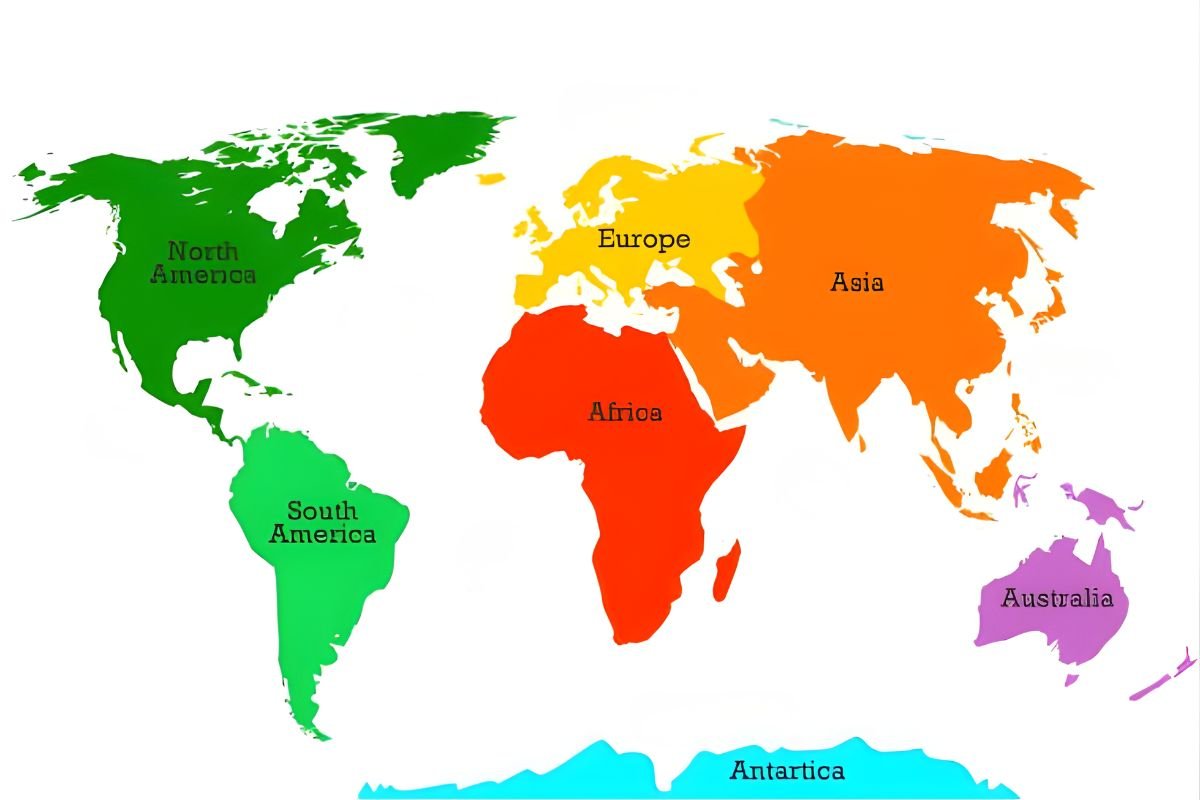
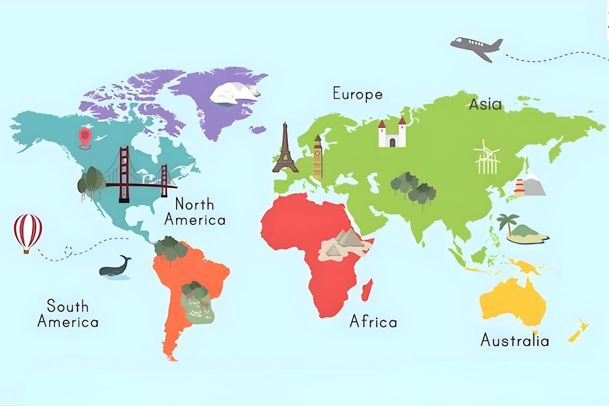
A continent is a large, continuous landmass on Earth. These vast regions are defined mainly by geography, tectonic plates, and natural boundaries such as oceans and mountain ranges. Today, most geographers recognize seven continents: Asia, Africa, North America, South America, Antarctica, Europe, and Australia.
Continents formed over millions of years through tectonic movement. Scientists believe that Earth’s land once existed as a single supercontinent called Pangaea. Over time, shifting plates caused it to split and drift apart, creating the continents we know today.
Each continent has its own climate patterns, ecosystems, and cultural diversity. For example, Asia is the largest and most populous continent, while Antarctica is almost entirely covered by ice and has no permanent residents. Understanding the relationship between geography and governance is key to grasping the idea of the continent and country.
List of Continents and Their Countries
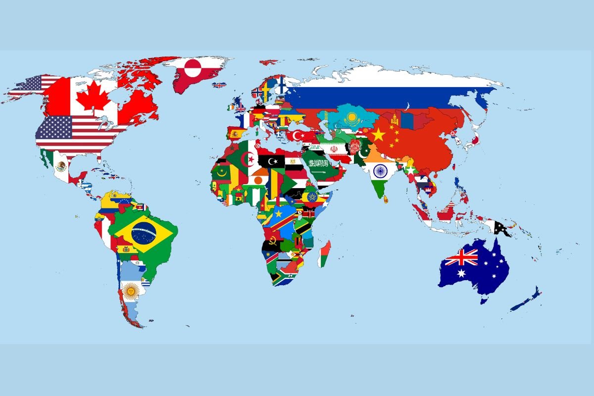
Every continent contains multiple countries, each with its own government, borders, culture, and population. The distribution of countries varies widely depending on historical development and political evolution.
Here is a simplified overview of continents and examples of countries located within them:
➤ Asia
- China
- India
- Japan
- Saudi Arabia
- Indonesia
➤ Africa
- Nigeria
- Egypt
- Kenya
- South Africa
- Morocco
➤ Europe
- France
- Germany
- Italy
- Spain
- United Kingdom
➤ North America
- United States
- Canada
- Mexico
- Cuba
- Guatemala
➤ South America
- Brazil
- Argentina
- Chile
- Peru
- Colombia
➤ Australia (Oceania)
- Australia
- New Zealand
- Fiji
- Papua New Guinea
➤ Antarctica
- No sovereign countries; governed by international agreements such as the Antarctic Treaty System.
This list illustrates how the concept of continent and country organizes the planet into large natural regions and smaller political units.
Cleanest Country in the World Reveals Eco Secrets You Must Know
The Cleanest Country in the World in 2026 tops global environmental rankings thanks to outstanding air, water, and waste standards. Examining the top-10 performers reveals how choice policy and culture create planet-friendly nations.
Number of Countries by Continent
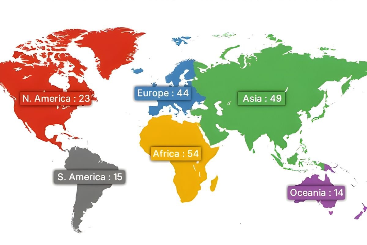
The number of countries within each continent differs significantly due to historical colonization, cultural divisions, and political developments.
Approximate number of countries by continent:
| Continent | Number of Countries |
|---|---|
| Africa | 54 |
| Asia | 49 |
| Europe | 44 |
| North America | 23 |
| South America | 12 |
| Oceania | 14 |
| Antarctica | 0 |
Africa contains the most countries, largely because colonial borders were later transformed into independent nations during the 20th century. Meanwhile, South America has fewer countries but covers a vast geographic area.
Understanding these numbers highlights how the idea of a continent and country reflects both natural geography and human history.
Differences Between Continents and Countries
Although people sometimes use these terms interchangeably in casual conversation, continents and countries are fundamentally different concepts.
1. Definition
A continent is a large geographical landmass, while a country is a political entity with defined borders and a government.
2. Formation
Continents are formed through geological processes such as tectonic plate movements. Countries are created through historical events, treaties, wars, and political agreements.
3. Size and Scope
Continents are enormous and may include dozens of countries. Countries are smaller units within those continents.
4. Governance
Continents do not have a single government. Countries, however, operate under their own political systems and laws.
5. Recognition
Continents are recognized globally based on geography, while countries are recognized internationally through organizations such as the United Nations.
These distinctions clarify why understanding a continent and country helps us better interpret maps, global politics, and international relations.
Why Continents and Countries Matter?
The division of Earth into continents and countries is more than a simple classification system. It influences nearly every aspect of global life.
6. Cultural Identity
People often identify strongly with their country and sometimes with their continent. These identities shape language, traditions, and cultural heritage.
7. Political Organization
Countries govern themselves through political systems such as democracies, monarchies, or republics. International cooperation often occurs at the country level.
8. Economic Systems
Trade agreements, markets, and economic partnerships are usually organized between countries, though continental alliances like the European Union also exist.
9. Education and Geography
Understanding global geography begins with learning the locations of continents and countries.
10. Travel and Tourism
Passports, visas, and international travel rules are determined by countries, while continents help travelers understand broader regional cultures.
These factors show how the concept of a continent and country plays a key role in shaping global interactions.
Read More Interesting!
- Budget-Friendly And Best Countries to Visit in South America
- 12 Oldest Countries in the World That Still Carry Their Ancient Roots
Interesting Facts About Continents and Countries
The world’s geography includes many fascinating facts that reveal the diversity of our planet.
- Asia covers about 30% of Earth’s total land area and contains more than half of the global population.
- Africa is the only continent located in all four hemispheres.
- Antarctica holds around 70% of the planet’s fresh water in its ice sheets.
- Russia is the largest country in the world and spans two continents: Europe and Asia.
- The smallest independent country is Vatican City.
- Some countries, such as Turkey, lie partly on two continents.
These examples show how geography and political boundaries intersect across the world.
How Continents and Countries Are Formed?
The formation of continents and countries involves completely different processes.
Continents form through geological activity. Earth’s crust is divided into tectonic plates that move slowly over millions of years. When these plates collide or drift apart, they reshape landmasses and create continents.
Countries, however, emerge from human history. Borders can change due to wars, independence movements, colonization, and international agreements. For example, many African countries gained independence in the mid-20th century after the decline of European colonial rule.
In some cases, countries merge or split depending on political decisions. The creation of new states demonstrates how dynamic national borders can be compared to the relatively stable nature of continents.
Conclusion
We can better comprehend the world map and global society when we are aware of the distinctions between continents and nations. While nations reflect human history, government, and political structure, continents are the planet’s principal landmasses created by natural geological forces.
We can better understand cultures, economies, and international relations by understanding the intersections between geography and politics. Every region of the world is shaped by both natural landscapes and human boundaries, from the vast icy plains of Antarctica to the densely populated cities of Asia.
In the end, understanding how a continent and country fit together reveals our world’s intriguing structure and the intricate narrative behind its maps.
Thank You For Reading!
See More
Best Countries for Gender Equality: Leading the Way in Social Progress